AllyNav R10 Manuale utente
1
SHANGHAI ALLYNAV TECHNOLOGY CO., LTD
R10 Operation Guide
Shanghai AllyNav Technology Co.,Ltd
Shanghai
China
GNSS Receiver
Version 1.0

2
SHANGHAI ALLYNAV TECHNOLOGY CO., LTD
Content
1.R10 Specifications.....................................................................................................................3
1.1 Technical features........................................................................................................ 3
1.2 Technical parametrest.................................................................................................4
1.3 Exterior dimensions ..................................................................................................... 6
1.4 Pictures of actual use scenarios............................................................................... 7
2. R10 Instructions ........................................................................................................................8
3. Software Description...............................................................................................................9
3.1 Software profile.............................................................................................................9
3.2 Device connect........................................................................................................... 10
3.3 Point Survey.................................................................................................................12
3.4 Point Stakeout.............................................................................................................15
3
SHANGHAI ALLYNAV TECHNOLOGY CO., LTD
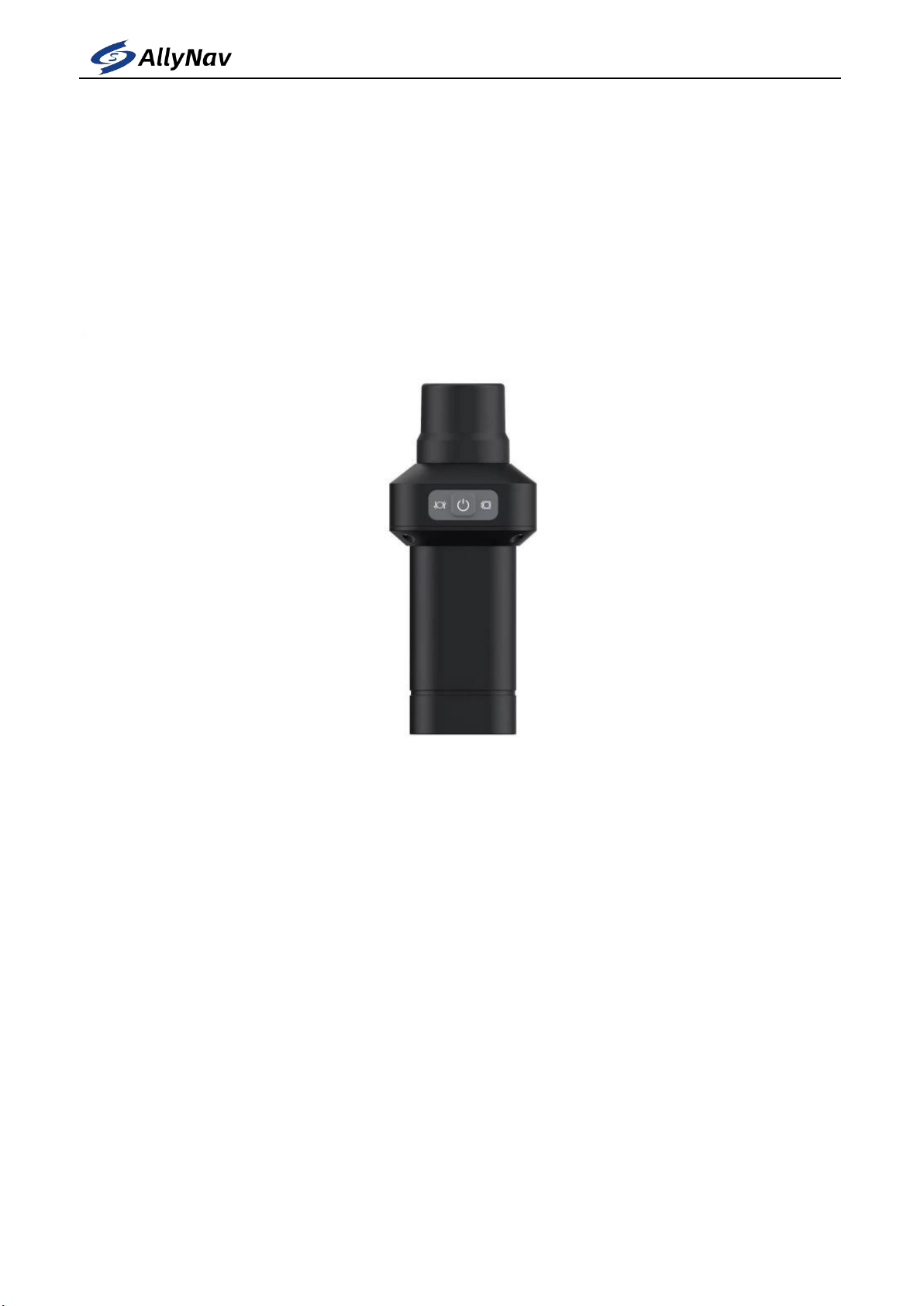
1. R10 Specifications
R10 portable high-precision locator is a lightweight, simple and practical high precision
GNSS RTK receiver, which is a low-cost solution for both portable and high-precision
positioning.
The R10 supports five stars and sixteen frequency positioning data, adopts
high-performance aluminum alloy body, built-in Bluetooth module can be used with
Android cell phones, can be widely used in engineering survey, geological survey, precision
agriculture, land survey, unmanned, geographic information, water survey, aerial
photogrammetry and other scenarios.
1.1 Technical features
Small size and high integration, the system can integrate high-capacity battery, GNSS
antenna, satellite positioning module, Bluetooth, etc..
High accuracy and low power consumption, using BeiDou, GPS, GLONASS, Galileo, QZSS
and other five stars and 16 frequencies, which can guarantee the positioning accuracy in a
variety of complex environments.
Adopting universal standard TYPE-C charging interface, supporting charging of
rechargeable batteries and supporting TYPE-C upgrade.
Standard IP54 waterproof and dustproof design.
Built-in 4.0 Bluetooth module, which supports a wide range of cell phone connections for
the AnTai.
Ultra-long battery life, low power consumption, built-in 4800mAh high-capacity battery,

4
SHANGHAI ALLYNAV TECHNOLOGY CO., LTD
supporting more than 16 hours of continuous use.
The total weight of the equipment is 0.55kg, small and light, easy to carry.
Flexible in use, can be handheld or screwed directly onto the alignment bar for
measurement.
Software with standard version of measurement software or flagship version of
measurement software with functions such as measurement, pointing and CAD placement.
Software support for various CORS systems as well as Thousand Seekers and Six Points, with
a free 1-year China Mobile national high-precision RTK positioning service.
1.2 Technical parametres
Signal Tracking
bds b1i/b2i/b3i/ b1c/b2a
GPS L1C/A/L2P(Y)/L2C
GLONASS L1/L2
Galileo E1/E5a/E5b
QZSS L1/L2/L5
Cold start time: <25s
Initialization time: <5s (typical)
RTK initialization reliability: >99.9%
Recapture: <1s
Accuracy index
Single point positioning.
Plane: 1.5m
Elevation: 2.5m
RTK accuracy.
Plane: ±(10+1.0×10⁻⁶ ×D)mm
Elevation: ±(20 + 1.0 ×10⁻⁶ ×D) mm, D is the baseline distance in mm

5
SHANGHAI ALLYNAV TECHNOLOGY CO., LTD
Data output
Differential data: RTCM 3.3/3.2/3.1/3.0
Positioning data: NMEA-0183
Electrical parameters
Endurance: ≥16h
Input voltage: DC5V ≤1A
Battery capacity: 4800mAh
Power consumption:1w
Physical Properties
Operating temperature: -45℃~+75℃
Storage temperature: -55℃~+85℃
Physical size: Φ165mm*70mm
Protection level: IP54
Impact and vibration: resistant to 2m drops
Button: 1 button
Indicator lights: 2 LED indicators
Weight: 0.55kg
Data interface.
Data refresh rate: 1Hz
Baud rate: 115200
Interface mode: standard TYPE-C interface
Bluetooth: BT4.0
6
SHANGHAI ALLYNAV TECHNOLOGY CO., LTD
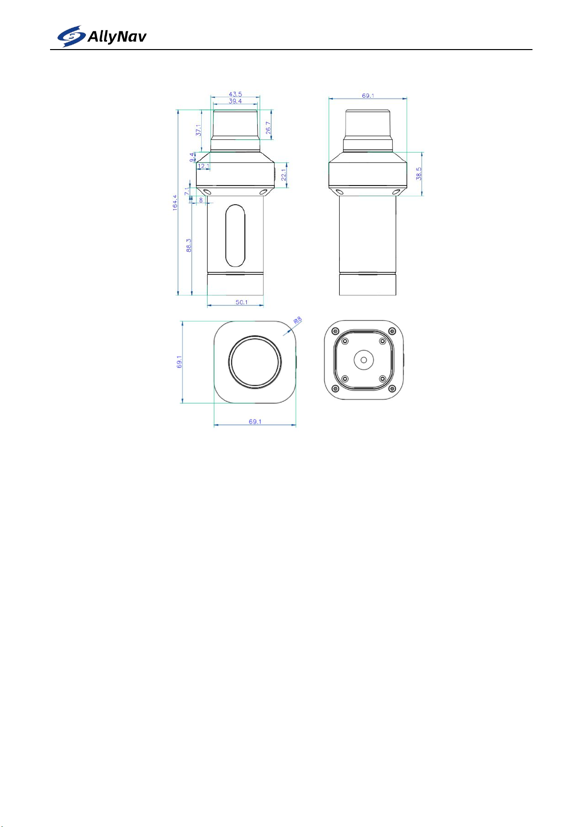
1.3 Exterior dimensions
7
SHANGHAI ALLYNAV TECHNOLOGY CO., LTD
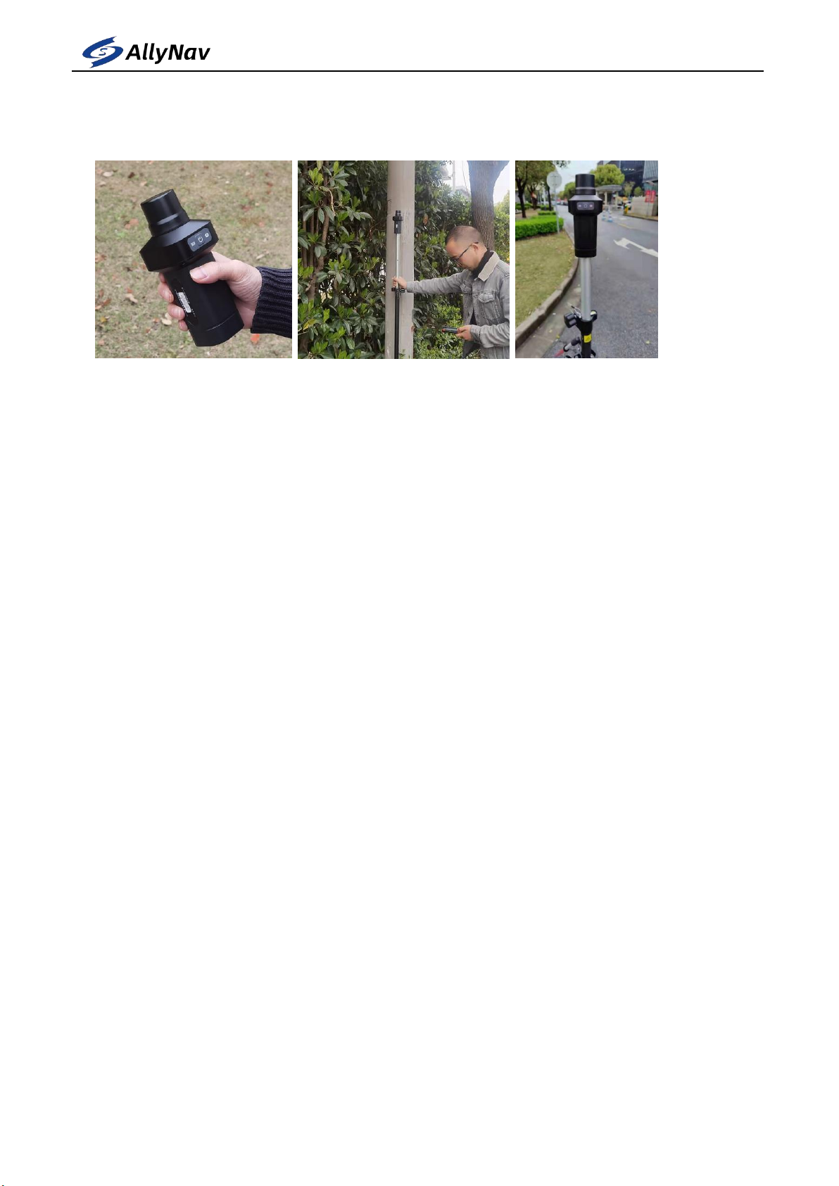
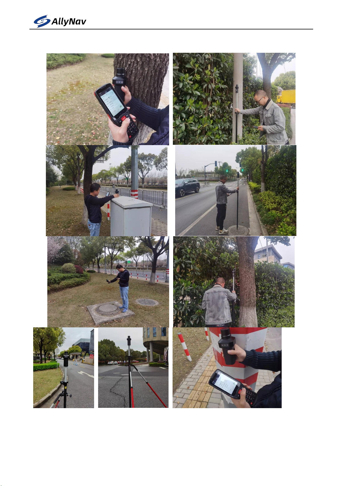
1.4 Pictures of actual use scenarios
8
SHANGHAI ALLYNAV TECHNOLOGY CO., LTD
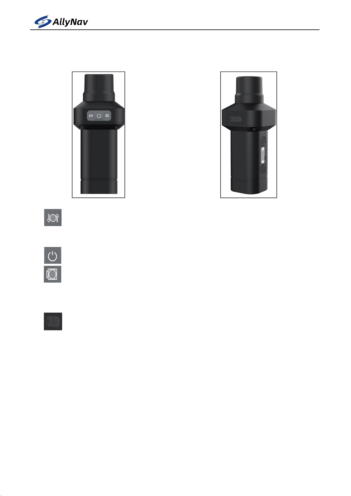
2. R10 Instructions
Connection indicator light : The red light flashes when the device is not
connected to the mobile phone ; the red light is always on when the device is connected
successfully
Power button: Press and hold for two seconds to turn on or off
Power indicator light : The red light is always on in normal working state ;
the red light is flashing when the device is low in power; the green light is
flashing in the charging state ; the green light is always on when the battery
is full
Charging interface: use TYPE-C charging interface, you can use the standard
charging line or the conventional data line that can realize the
communication function
Notice:
1. Please avoid placing the charging port in water or staying in a humid
environment for a long time.
2. When not charging, please cover the dust-proof silica gel to avoid damage to the
device caused by water and dust.

9
SHANGHAI ALLYNAV TECHNOLOGY CO., LTD
3. Software Description
3.1 Software profile
AllyPad software is an engineering survey application software developed by
Shanghai AllyNav Technology Co., Ltd. based on GNSS high-precision location
application. The developers integrate based on years of surveying and mapping
development and market experience accumulation, combined with the use habits of a
large number of industry users and Android operation style habits.The software has a
humanized operation process of simple operation and easy to use,
high-precision position survey and collection, point and line setting out, powerful
road design and construction setting function and CAD Figure setting function,
convenient functional menu display and convenient user customized design.
The following introduces the basic functions of the software: The software
mainly includes four parts: Proiects, Device, survey, and tools.
10
SHANGHAI ALLYNAV TECHNOLOGY CO., LTD
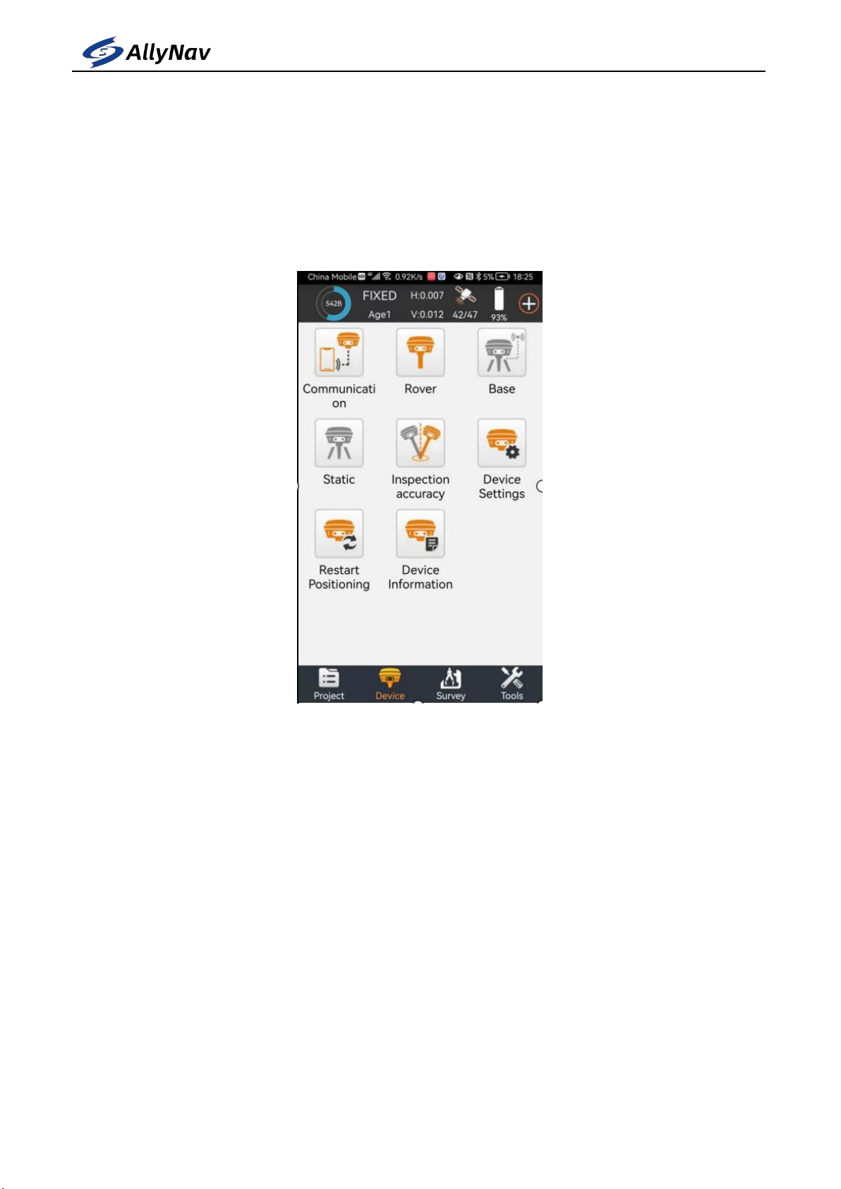
3.2 Device connect
At the main software interface, click [Device] on the corresponding function
menu, as shown in Figure 3-1.The instrument includes Communication, Rover, Base,
Static, Inspection accuracy, Device Setting, Restart Positioning, Device information
and other functions.
Figure 3-1
Click [Device] -> [Communication], as shown in Figure 3.1-1.Select the
instrument manufacturer, instrument type and Communication mode, then select the
R10, and click "Connect" to complete the equipment Communication.After the
device is successfully connected, it will return directly to the main interface of the
software, as shown in Figure 3-2.Enter the communication setting, as shown in Fig.
3.2-2, click Stop the section equipment Communication.
1. Selection of the instrument manufacturer: the software supports the joint
navigation and the positioning equipment access of many other GNSS instrument and
equipment manufacturers, as shown in Figure 3.2-3.
2. Instrument type: choose R10
Indice
Altri manuali AllyNav Strumento di misura


